An illustrative Tessure world
Resort & marina
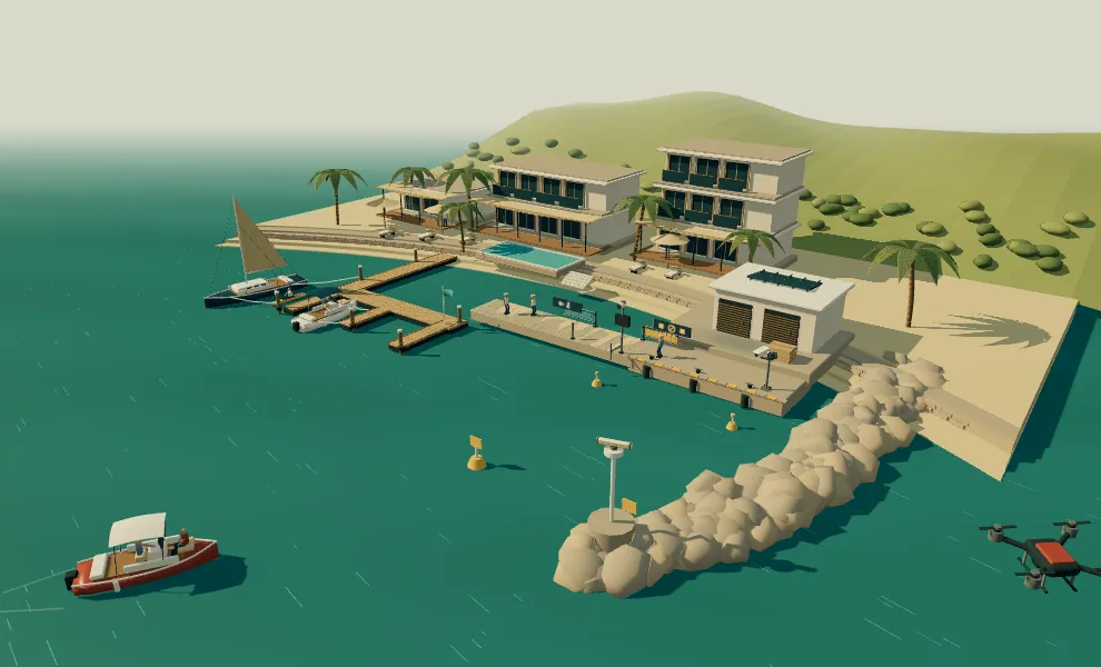
An unauthorized craft and a separate aerial surveillance threat approach a fictional resort. Independent observations lead to a human decision and visible shore protection. Explore the authored incident, the evidence behind the decision and the physical response. This is an authored illustration, not working detection software.
World 03 / Resort & marina
Two approaches to the restricted quay
An unauthorized craft and a separate aerial surveillance threat approach a fictional resort. Independent observations lead to a human decision and visible shore protection.
The illustration plays from beginning to end, including the operator’s review and response. Pause or jump to any moment to explore; these controls do not operate a real site.
The idea this world exploresIndependent water and air observations support one human decision, followed by visible protection of the public waterfront.
Read the story as text
Restricted water & aerial surveillance
A public waterfront beside a working quay
Fictional red-team simulation. Visitors walk the public promenade; a kayak rests at the pontoons. Beyond the amber water markers, the service quay and its staff-controlled gangway are restricted. The burgundy craft has two unauthorized occupants; the separate quadcopter is a hostile observation actor. Those roles are authored ground truth, not identities inferred by sensors.
Two approaches, two observation channels
The unauthorized craft advances toward the marked service basin. Separately, the hostile quadcopter descends toward an observation leg over the restricted shore. The open-array radar contributes the water track; the pitched sky camera contributes the air track.
Water radar: A surface craft advances toward the amber water markers.
Sky camera: A separate aircraft approaches above the restricted shore.
Not established: The water radar is not shown detecting the aircraft. No common operator or identity is established.
The craft crosses the restricted approach
The two-person craft passes between the amber markers toward the working quay. Visitors remain on the public side; the service gangway is still open under staff control.
Water camera: The hull crosses the marked water boundary and continues inward.
A craft with two occupants
The water view corroborates the hull, the two seated occupants and the continuing approach. These are visible features; their unauthorized role belongs to the fictional script.
Water camera: Two occupants and an inward-moving hull are visible.
Not established: Faces, identity and intent are not inferred from this picture.
A separate surveillance pass
The sky view shows the quadcopter banking along the shore. Its rotors turn and its gimbal points toward the service area. This independently corroborates the authored aerial observation threat.
Sky camera: A banked aerial pass along the restricted shore.
Not established: No RF interception, shared operator or counter-drone control is depicted.
One review, separate water and air tracks
The proposed local system links the simultaneous restricted-water and aerial observations by place and time. At the shore control, a short amber link joins the separate blue water and amber air observation tiles. It preserves two tracks rather than claiming one identified operator.
Proposed local correlation: Water and air observations are grouped into a reviewable incident.
Shore control: The local warning indicator is lit; guests and the open gangway have not yet moved.
Not established: The connection is contextual; no common operator is established.
The operator checks both tracks
The operator reviews the separate observations while the craft holds off the quay, then authorizes a shore warning and protection of the nearby visitors.
Illustrative decision: The operator authorizes a warning, secured service access and visitors moved back.
Current site state: Open service gangway, visitors nearby, separate water and aerial tracks.
Not established: Departure has not happened; this in-story decision does not control the aircraft.
A warning from shore; clear the gangway
After the operator’s authored review, the visible speaker/beacon warning activates. The attendant steps from the service side through the open gangway and onto the public side before its powered leaf moves. Visitors turn back along the promenade.
Authorized shore sequence: Activate warning, clear the gangway and guide visitors away.
Restricted access is closed
The service leaf reaches its closed stop after the attendant clears its sweep. The attendant gestures west; visitors continue to the protected public side.
Service gangway: The leaf is closed with no person in its swept space.
Attendant: An unarmed gesture redirects the visitors.
Visitors back; the craft turns out
Both visitors are behind the public line and its barrier is closed. The craft begins a slow turn away from the quay. This is the scripted adversary response to the visible shore warning, not guaranteed deterrence.
Public promenade: Visitors are behind the held route barrier.
Water camera: The craft begins turning outward.
Not established: The craft withdrawal is authored; no assured efficacy is claimed.
Separate outward routes
The craft follows a clear route back toward open water. Independently, the hostile drone finishes its observation leg, banks away and departs on its own aerial route. Its retreat is a scripted choice; shore equipment does not jam or force it.
Water camera: The craft is moving outward; its wake follows speed and heading.
Sky camera: The drone leaves its shore observation leg.
Not established: No forced withdrawal or counter-drone capability is shown.
Follow departures to the coverage edges
The water and air tracks reach the edges of the illustrated observation area on separate routes. The gangway and public barrier stay held while the attendant starts a shore-side inspection.
Separate tracks: Both actors are departing the restricted waterfront.
Attendant: The service entrance remains controlled during the check.
The tracks have left this observation
The craft is outside the inlet approach and the drone is beyond the aerial view. Warning indicators stop; the attendant looks across the closed service access to check the quay.
Coverage-edge record: Water and aerial departures recorded separately.
Not established: The record does not claim tracking beyond the illustrated coverage or identify either operator.
The attendant completes the shore check
The attendant stops at the service boundary and verifies the pictured quay clear. A green record tile marks this completed shore check. Restricted access remains closed.
Shore check: The attendant has reached the controlled boundary and checked the visible quay.
Local record: Departure observations and the completed shore check are recorded.
Public route reopened; service access controlled
The public barrier is open and visitors resume their promenade walk. The restricted service gate stays closed. The record retains two departed tracks, protective shore actions and the completed local check.
Public route: The promenade reopens after the check.
Restricted service gate: Service access remains closed.
Not established: No identity, universal site safety or guaranteed outcome is inferred.